Doreen (recently established) is a suburb that has developed over the past 25 years and is renowned for its landscape character, river red gums, public spaces and educational facilities.
The suburb is split over two municipalities. Its urban area is located in the City of Whittlesea, while its rural area is located outside the urban growth boundary in the Shire of Nillumbik. The urban area is serviced by four local neighbourhood centres, including Laurimar and Ashley Park.
With 28,604 residents now calling Doreen home, it is expected to have around the same number of residents in 2040. Doreen has a high number of primary and secondary schoolers compared to other age groups (22.8% compared to CoW 17.5%).
The suburb is also home to the Costa Mushroom exchange, which is one of the largest employers in the municipality and is located on the eastern bank of the Plenty River. The Plenty Gorge park adjoins the river to the south of Bridge Inn Road and protects significant environmental values in the vicinity of the river.
Refer to the next sections to explore current and past development plans shaping Doreen’s future. Each plan provides a clear vision for how the land in the area can be used and developed.
The Development Plan applies to 1025 Yan Yean Road, Doreen and will guide the development of the site for residential purposes.
What the plan includes
The purpose of the Development Plan is to:
- Guide orderly planning for the site and the locality consistent with Council strategic policy expectations
- Identify preferred land use outcomes for the land
- Incorporate the priorities of specialist consultant works into future development of the site
- Reinforce and enhance the local character of the broader surrounding area
- Communicate the local road networks and access expectations for the land
- Provide a clear framework detailing the future planning outcomes and objectives for the land to inform any future application for planning permit.
View the plan
1025 Yan Yean Road Doreen Approved Development Plan 2024(PDF, 8MB)
The proposed Development Plan for Precinct 2A applies to a number of properties in Doreen, and will guide the future use and development of the land.
About the Development Plan
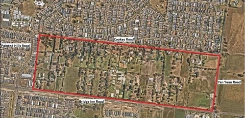
The proposed Development Plan applies to a number of properties in Doreen bound by Cookes, Yan Yean and Bridge Inn roads and existing residential development. The area is referred to as Precinct 2A.
The proposed plan will guide the future use and development of land for residential purposes.
Area covered by the plan
The proposed development plan applies to the land shown below, referred to as Precinct 2A.
The plan does not propose development on any surrounding properties outside this area.
What the plan does
The preparation of a Development Plan is a statutory requirement in accordance with the Development Plan Overlay (Schedule 5) in the Whittlesea Planning Scheme, which affects the properties highlighted above.
The proposed Development Plan consists of both text and plan components and provides for a road layout, future residential development parcels and open space network.
Exhibition of the plan
As part of a non-statutory exhibition process, we notified potentially affected property owners/occupiers and relevant Government agencies about the proposed Precinct 2A Development Plan, and gave them the opportunity to make a submission.
The Development Plan was exhibited from 20 April 2023 to 22 May 2023.
We'll publish updates on the development plan to this page as they become available.
Download the plan
At the Council Meeting on 16 July 2024, Council resolved to approve the final development plan. The plan can be accessed here.
Precinct 2A Doreen Development Plan(PDF, 22MB)
Explore other development plans below:
Old development plans upon request
If you require the following documents, please email strategic.planning@whittlesea.vic.gov.au with your request.
- Ashley Park Development Plan 2009
- Bond Property Development Plan 2003
- Eminence Estate, Cookes Road Development Plan 2007
- Laurimar At Yan Yean ODP 1996
- Mitchells Run Development Plan 2002
- Orchard Park Development Plan 2003
- Yan Yean Rd Doreen DP Vaucluse Wilbow Corp 2004